

Michigan's best drives for seeing fall colors
Fall Colors
Fall leaf color in Southeast Michigan took a little longer to peak this season due to changes in our weather pattern. In this Weather or Not, Meteorologist Lori Pinson discusses our October weather changes and how that affects leaf colors.
(FOX 2) - With the air cooling down and the leaves beginning their color transformation, there's no better time of the year to see Michigan in all its majesty.
While the entire state will see green leaves morph into shades of yellow, red, and orange, there are some excursions through the state that can't be missed for those who know where to look.
And if you need to know the perfect time to check out the state's fall foliage, go to FOX 2's guide here.
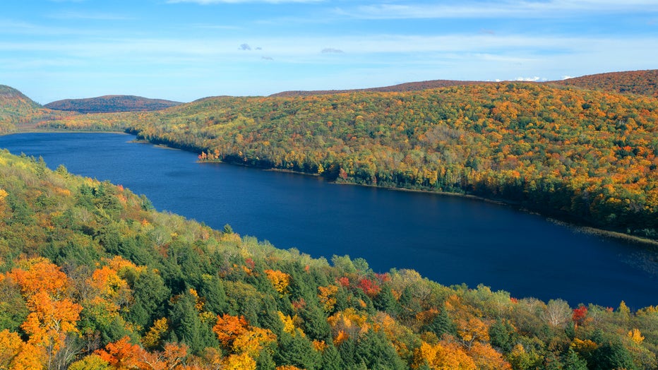
Autumn color at Porcupine State Park, Michigan's Upper Peninsula, Michigan (Photo by: Joe Sohm/Visions of America/Universal Images Group via Getty Images)
Michigan among best places to visit in fall, study says
Lower Peninsula Drives
- M-22 runs along the far west Michigan coast and goes by several water bodies, including Portage Lake, Crystal Lake, and Glen Lake. It continues by Sleeping Bear Dunes and up the Leelanau Peninsula all the way to Northport.
- M-37 goes up Old Mission Peninsula, which is located in between each arm of Grand Traverse Bay. The drive ends at Mission Point Lighthouse.
- US-31 is another road that tracks along much of Michigan's west coast, extending beyond Traverse City up all the way to near Mackinaw City. It's the drive between those two cities that offers sights of Lake Michigan through a forested coastline with plenty to see.
- The Blue Star Highway is a memorial highway between South Haven and Holland and runs about 42 miles along Lake Michigan in the southern half of the lower peninsula.
- Lake Shore Avenue is another local highway that runs through the rural tracks of west Michigan, connecting Grand Haven to Holland
- Highway 119 is a rural road that splits off from M-31 and heads west along the Lake Michigan coast. It's near the northern tip of the lower peninsula and extends from Harbor Springs to Cross Village. It's a can't-miss for scenic drivers.
- US-23, for all its construction and congestion offers the best way to see the east coast of Michigan's Lower Peninsula at its best. To do that, start at Tawas City and head north. The drive will take people along the Lake Huron coast and through an array of state forests.
Upper Peninsula Drives
- M-26 is about as north as someone can get in Michigan without submerging themselves in Lake Superior. The Keewenaw Peninsula highway runs from Houghton north along Torch Lake before meeting Copper Harbor, an old mining town. It connects with US-41, which driven together offers a perfect loop of the peninsula.
- US-2 takes drivers west as soon as they get off the Mackinac Bridge. If drivers aren't going up the interstate to Sault Ste. Marie, they might be taking US-2 along the northern shore of Lake Michigan through several towns that dot the UP. It ends in Rapid River.
- M-64 is its own kind of northern Michigan beast and one of the western most roadways in the state. To get here, drivers will need to reach Ontonagon on Lake Superior. From there, they can travel west down into Michigan's Porcupine Mountains - one of the best ranges in the country to see changing leaves. It ends on Lake Gogebic.
- H-58 is for the backpackers and campers of Pictured Rocks. It runs from Munising through some of the peninsula's most isolated land, offering several ways of visiting the National Lake Shore. Or, drivers can take it all the way to Grand Marais.
- The Black River National Forest Scenic Byway takes drivers about as west as they can go in the UP. Completely surrounded by trees, it starts near the Iron County Airport and goes up to Black River Harbor.
More Fall stories:
- Cider mill guide: Where to get donuts, apples this fall in Southeast Michigan
- When will leaves change color in Michigan? Check the fall foliage map
- Krispy Kreme releases new autumn orchard collection for fall season