Live updates: First round of storms clear through Metro Detroit, more possible Tuesday afternoon
SOUTHFIELD, Mich. (FOX 2) - FOX 2 is tracking severe weather throughout the day on Tuesday. Above is live radar which does not have any audio. Below, you will find live streams from the FOX 2 weather team and a live update as these storms push through southeast Michigan.
If it seems like every day for the past week or so has been the same outside - that's because it basically has. But finally - FINALLY - it's about to lift. You just have to get through one more day. Just one. More. Day.
Well, for now at least. Tuesday's forecast will again be hot and humid with a Heat Index close to 95 degrees. But more important than the heat is the threat again for showers and storms. Which started bubbling up around 1:15.
To be alerted on your phone of possible weather situations, get the FOX 2 News app for only the most urgent updates of weather and what you need to know. It's free for your iOS device or your Android. And - it's 100% free.
Around 1:15 p.m., a Severe Thunderstorm Warning was issued for Northern Livingston County, parts of Oakland County, and Genesee County. Around 2 p.m., those warnings were cleared but another one was issued in Washtenaw County until about 3 p.m.
Derek Kevra and Rich Luterman gave an update from the weather office as the storms pushed into Detroit:
What to expect on Tuesday
The storms and showers that pop up will likely impact Southeast Michigan and Tuesday has probably the best chance this week.
Timing-wise, our highest probability exists between 4 p.m. and 8 p.m. Storms are currently developing in northern Illinois and northern Indiana, and their trajectory is again aimed at us.
Follow below for more updates on the weather. Mobile app users tap here to follow live.
RELATED: Explaining our relentless heat with a boiling pot of water
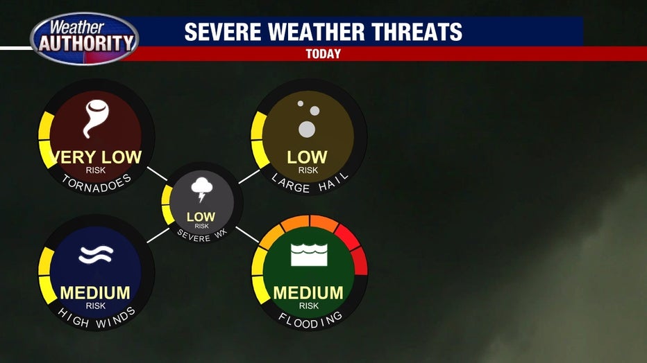
These storms could pack a punch with strong winds, lightning and heavy downpours. After receiving between 2 inches and 8 inches of rain over the last 3 days even a little water could cause flooding concerns.
The main threats we're looking for Tuesday afternoon and evening are high winds and flooding.

Storms may continue after 8 p.m. but will likely transition from strong/severe to mostly rain as we approach midnight. But there's no relief from the heat or humidity when the sun is gone as our low drops only to 71.
What to expect for the rest of the week
The frustratingly stationary system will FINALLY move on as we head through Wednesday thanks to a shove of cooler air in Northern Canada. Remember the lid we talked about on Monday? This is the movement we needed to get the lid off of the high pressure over Metro Detroit.
A second cold front arrives Thursday and will offer a much-needed break from the humidity by the Holiday weekend.
But with the two cold fronts comes the possibility of more showers and storms as they pass through.
The good news? Dry air finally arrives by Friday, just in time for the Fourth of July weekend.
Keep up to date with the FOX 2 Weather app. It's available for free to all iPhone, iPad and Android users.

