Michigan's winter weather timeline: Snow, wind gusts, and potential power outages incoming

End of the week snow forecast
Light snow falls Thursday before the next storm that arrives Friday into Saturday.
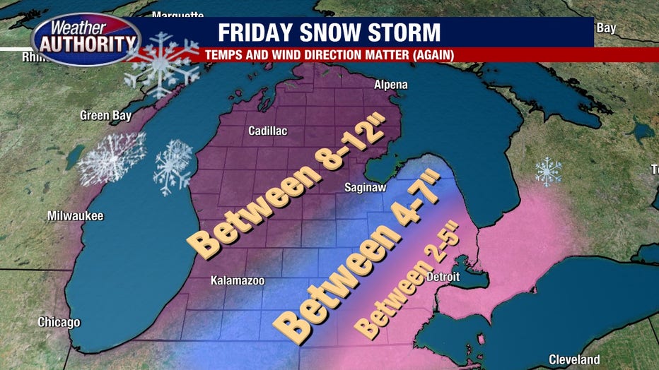
(FOX 2) - A sharp change to winter continues to end the work week and kick off the weekend as another round of rain and snow impact us in Southeast Michigan. Friday night's storm will follow a similar trajectory to the one we saw earlier this week, and while it won't be an exact replica, there are some similarities.
Let's talk timeline:
SNOW BEGINS:
Friday, around 2 p.m.
The storm will rapidly intensify across the Great plains and push through the Midwest on Friday during the day.
The leading line of precipitation will be snow as it moves into Michigan from northern Indiana and northern Ohio around 2:00 p.m. on Friday. Watch for the winds to start increasing as well, with gusts reaching nearly 30 mph.
SNOW CHANGES TO RAIN:
Friday, around 9 p.m.
Several hours of snow will impact us across Michigan between 2:00 and 9:00 p.m. on Friday.
This will accumulate into several inches. Of course, this is terrible timing for evening commutes and even bus routes for some locations. The snow will once again be heavy and wet and will likely stick to most surfaces.

RAIN AND WIND:
Friday to Saturday, between 9 p.m. and 1 a.m.
As the winds begin a quick shift to a southeast direction and travel over the warm waters of Lake Erie, we find ourselves in a similar situation to Tuesday's storm.
A milder air mass will shove into Southeast Michigan and change some of the snow into rain. On Tuesday, warm air spread all throughout Southeast Michigan. The question is, could that happen again?
Probably, although spots farther west may not have as dramatic of a precipitation change over time.
MORE: How much snow could fall this weekend
BACK TO SNOW, STRONGER WINDS:
Saturday 2 a.m. to Sunday at noon
Precipitation will switch back to snow early Saturday morning and continue throughout the day and into Sunday.
This will not cause major accumulating snow. However, some pockets may have heavy snowfall for periods of time. Early Saturday morning brings the strongest and most dangerous winds, which could gust to nearly 50 mph.
This is the type of wind that. combined with winter precipitation. could cause some power outages and slippery situations. Take great caution if traveling.

FRIGID TEMPERATURES:
Sunday
We wake up Sunday morning to temperatures in the teens and wind chills below zero. In fact, we will likely spend all of Sunday with frigid temperatures.


