

Winter Storm Warning issued for Southeast Michigan starting Wednesday
Metro Detroit likely to see a foot of snow Wednesday and Thursday
A massive winter storm spanning almost the entire midwest and much of the northeast is here and we expect to get about a foot of snow over two days.
DETROIT (FOX 2) - The National Weather Service has officially put Southeast Michigan and Metro Detroit under a winter storm warning starting Wednesday morning as a powerful snowmaker plows into the area.
The NWS issued the warning a little after noon on Tuesday and it will go into effect at 4 a.m. on Wednesday as our first major winter storm of 2022 is nearly here. The long-duration snowstorm could drop snow as much as one inch per hour in some spots.
The warning is in place until 7 a.m. on Thursday as Michigan expects to see 9 to 12 inches of snow.
MORE: What to have on hand if the power goes out during a winter storm
Want to get the latest news and weather updates from your phone instantly? Download the FOX 2 app today on Android and iPhone today. You can also sign up for our FOX 2 newsletters to have breaking news delivered to your email. Sign up here to have them sent to you.
When does the snow start?
We'll first see rain on Tuesday and temperatures will be above freezing for the first time in a while. But that relative warmth will soon drop below freezing and is causing perfect conditions for a heavy amount of snow.
When a cold front pushes into Michigan lat Tuesday night, the rain will turn into sleet and then snow. That will be around 11 p.m. Tuesday night and by the time we wake up Wednesday morning, there will already be several inches of snow on the ground.
Before the rain, sleet, and then snow even start, you NEED the FOX 2 Weather app. It's 100% free and gives you live radar, projections, and the alerts that are the most important for your day.

How much snow will Michigan get?
Buckle up Michigan. Steady, yet moderate snow will continue all day Wednesday and most of Thursday. At times, it will be heavy and, by the time it's all done, we're looking at grand snow totals of between 8-14 inches.
Wednesday will be the heavier of the two days, with snow continuing almost all day. By noon Wednesday, there will be nearly 2 inches of snow on the ground, and by dinner time closer to 3-4 inches.
By the time we wake up to go to work on Thursday, there could already be 6-7 inches accumulated on the ground.
MORE: 7 creative winter activities besides snowball fights that everyone will love
The snow continues Thursday too with a moderate to heavy pace at times. In fact, some rates on Thursday morning may be the heaviest we'll see throughout the entire winter storm.
By noon on Thursday it is likely that we have 8-10 inches on the ground... and we're not done!
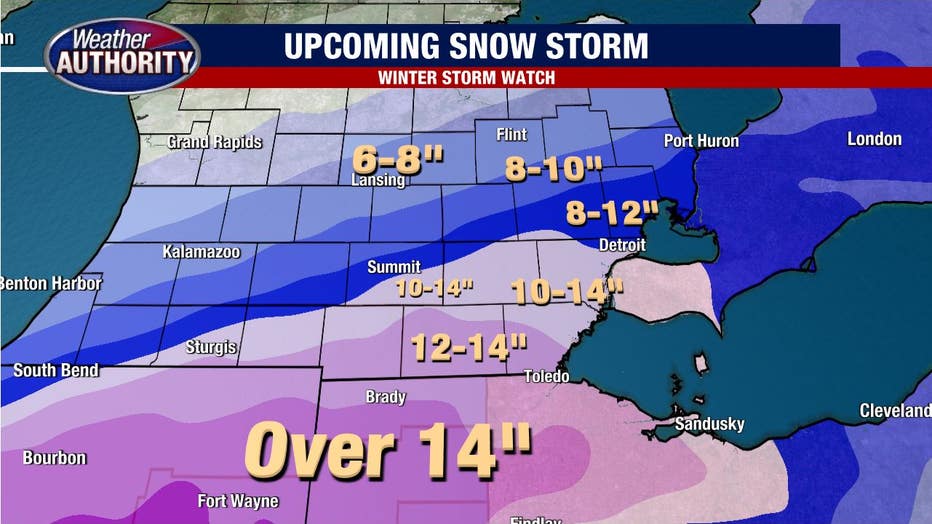
An additional 2-3 inches is still possible as most of the snow tracks out of Southeast Michigan by around 8 p.m. Thursday. The broad range is between 8-14 inches, but a more targeted number of 10-12 inches looks likely for most of us with some of us getting even more. Below is a more detailed breakdown:
Kalamazoo, Lansing, and Flint should all be in the 6 to 8 inch range. Oakland County and Macomb County should mostly get between 8 and 12 inches of snow while Detroit, Wayne County, and Washtenaw County will allow likely get between 10 and 14 inches. It only gets deeper as you go farther south.
Near the Ohio border, we're looking at more than a foot while Ohio and Indiana should each get more than 14 inches.
Will schools close from the snow in Southeast Michigan?
Yes.
Schools will absolutely close through pretty much the entire area. It will be up to each district whether they close in advance of the storm or not.
Stay up to date on school closings on this page here - where you can also watch our live coverage all day every day.
Detroit snow records
It's going to be the biggest snow system since December of 2016 and perhaps a top 10 snowstorm of all time. If we see some totals of near 15 inches that would not surprise me.
Following the snow will come an extremely frigid BLAST of air. High temperatures to end the week won't get out of the teens and overnight lows Friday night will plummet to -1 with a windchill of -15 degrees.