Winter Weather Advisory: Metro Detroit wakes up to snow. How much to expect
DETROIT (FOX 2) - A Winter Weather Advisory is in effect for most of southeast Michigan as a snow system moves into Metro Detroit just in time for Friday's commute.
The flakes started flying around 5:15 Friday morning for most of Metro Detroit – and in the northern communities, it started to stick pretty quickly.
It's leading to dozens of crashes reported across Metro Detroit – with freeways across the entire area slowing down.
Snow brings tricky travel to Metro Detroit for Friday
Friday morning is bringing a spring snow system in Metro Detroit — and it’s going to make for a very tricky drive into work Friday morning.
Around 6 a.m. on Friday, a winter weather advisory was posted for Oakland County, Macomb County, St. Clair County, Livingston County, Lapeer County. The advisory means that the National Weather Service is concerned about a possible threat to life or property because of the weather.
Get location-based weather alerts on your mobile device by downloading the FOX 2 weather app and allowing notifications.
The snow is also leading to a large amount of school closings coming in. These are mostly in central and northern counties. Check the list of closings here.
Drivers should expect limited visibility for the commute to work with the heaviest stuff expected to be done by 8 a.m.
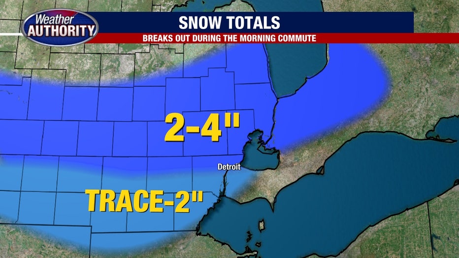
All told, we're not looking at a ton of snow – we're talking between 1 and 4 inches by the time the snow system is done. However, we haven't seen much snow over the winter so this spring snowmaker could catch many drivers by surprise. Even with the heaviest stuff early in the morning – that doesn't mean we'll be done for the day.
The snow will continue throughout the morning and most of the afternoon. By 10:00 PM on Friday night we should begin to see some of it tapering off.
The snow will not be falling consistently during this timeframe, however. We will see periods where it will start and stop depending on where the heavy moisture lines up. Of course, this will play a role in official totals, which will vary by location.
Starting in the southern communities of Lenawee and Monroe counties, snow totals will be significantly less. An inch or less of snow is expected, while some areas may not get any at all.
Traveling north into Washtenaw and Wayne counties, we expect between 1-2 inches for most locales. The higher numbers will be further north still in Oakland, Macomb and Livingston Counties. This "zone" will receive between 2-3 inches with some spots perhaps getting slightly higher than that.
The bullseye of the snowmaker will be in mid-Michigan where they could get between 4 and 7 inches of snow.
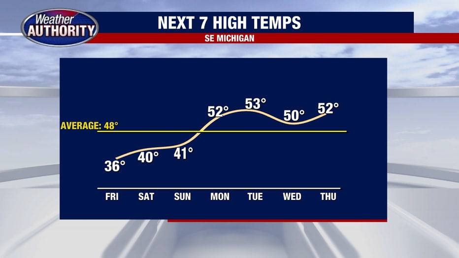
The good news is that we'll be in the 40s by the weekend and 50s next week. Which means this snow won't stay long.