Grand Blanc EF-2 tornado leaves trail of damage with peak wind speed of 115 mph
Grand Blanc residents clean up after tornado
A tornado touched down in Grand Blanc Wednesday morning, sending sirens blaring and downing trees and power lines. For some locals in mid-Michigan, the clean-up has just begun.
FOX 2 (WJBK) - The National Weather Service confirmed that an EF-2 tornado touched down in Grand Blanc Township in the early hours of Wednesday morning.
A path of damage was left throughout the area, as trees were uprooted, houses damaged and gas lines ruptured. The Enhanced Fujita Scale lists the wind speed of an EF2 tornado at 111 to 135 miles per hour. There were no reported injuries.
According to the NWS, the peak wind speed was 115 mph. It had a path width of 450 yards and had a length of 5.7 miles.
It was the second time a tornado has occurred in February over Southeast Michigan. The previous one happened Feb 28th, 1974 in southwest Wayne County.
For Grand Blanc locals, the damage was "devastating."
"Big, big, big trees," said Bob, wearing an old Michigan State University sweatshirt. He spent much of Wednesday clearing up the wreckage left behind. He was among those that heard pipes carrying pressurized gas breaking.
"You could hear the psssh like that, just like that was in our yard from gas. And that went on at least a couple hours," he said.
The tornado start time was 1:12 a.m. and 1:22 a.m.
Diana Holt, another neighbor cleaning up her home said the emergency sirens woke her family up out of a dead sleep.
"And to see all the damage here is just unbelievable," she said.
Among the hardest-hit portions of the region was Dort Highway, which could be shutdown for another day for clean-up. NWS storm data tracked the tornado's path after it touched down in Creasey Bicentennial Park.
- The tornado went east-northeast across Westminster Circle where multiple trees were snapped, two garage doors were blown out, and a roof was partially stripped from one home.
- The tornado continued tracking east-northeast across Porter Rd and Reid Rd where multiple limbs and trees were snapped.
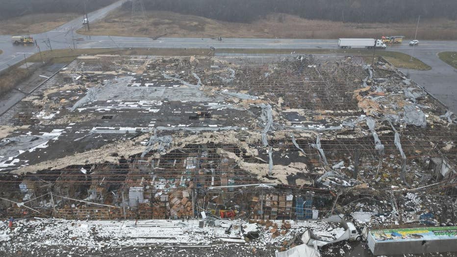
- The peak of damage occurred at an industrial complex at the intersection of Reid and S Dort Hwy. Damage to the complex included blown out non-load bearing walls and significant loss of roofing.
- Multiple transmission poles were also snapped along S Dort Hwy.
- Damages continued into the Indian Hill neighborhood near downtown Grand Blanc where multiple large trees were downed with some of them falling onto homes along Old Bridge Rd to Stonybrook Dr.
- The tornado tracked east northeast across Genesee Road to Belsay Road snapping tree limbs and uprooting pine trees before greater damage occurred along Moonstone Dr and Brookview Dr. Damage in these areas included widespread tree damage and one home with a garage door blown out and a roof partially uplifted.
According to storm data, the tornado weakened and lifted after it crossed Perry Road.
At least 2,000 customers are without power in the Grand Blanc Township area, according to the Outage Map by Consumers Energy, which can be found HERE.
Related:
- EF-2 tornado confirmed in Grand Blanc Wednesday morning by National Weather Service
- PHOTOS: Damage from the EF-2 tornado in Grand Blanc
Residents who sustained damage from the storm can report it to Genesee County Emergency Management through this form. You will be asked to provide information such as your name, address, type of insurance you have, and what kind of damage you experienced. You will also be asked to provide photos of the damage.

Overhead shot of storm damage which was posted on the Grand Blanc Township Facebook page.
Those with questions can reach the Emergency Management Division at 810-257-3064.
The EF Scale is as follows:
EF0.....65 to 85 mph
EF1.....86 to 110 mph
EF2.....111 to 135 mph
EF3.....136 to 165 mph
EF4.....166 to 200 mph
EF5.....>200 mph

