

Michigan severe weather: Live updates as strong storms arrive in Metro Detroit
FOX 2 - Strong storms with periods of heavy rain and conditions which could bring tornadic activity are rolling though Metro Detroit Wednesday.
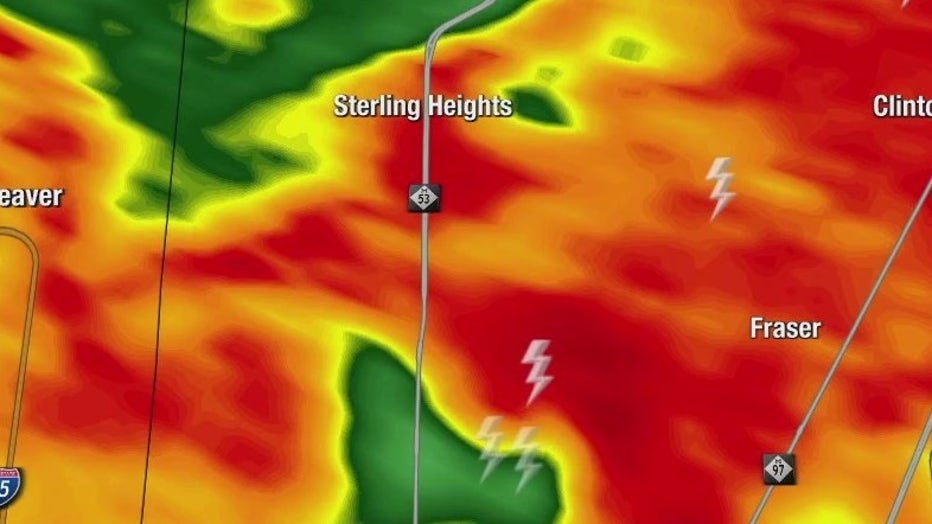
A confirmed tornado touched down during the first round of storms today in Fraser. The most active weather window is expected to be between 6 p.m. to 10 p.m.
Follow this page for weather updates as they break throughout the day.
7:30 p.m.:
The National Weather Service has confirmed that a tornado touched down in Fraser earlier today. More information is expected to be released regarding the region's tornadic activity on Thursday.
7:16 p.m.:
A severe thunderstorm warning has been issued for Monroe County until 8:30 p.m.
At 7:16 p.m. severe thunderstorms were located along a line extending from near Manchester to near Blissfield to near Swanton, moving northeast at 45 mph.
6:44 p.m.:
A severe thunderstorm warning has been issued for Livingston and Washtenaw counties until 8 p.m.
At 6:43 p.m. severe thunderstorms were located along a line extending from near Grand Ledge to near Leslie to near Grass Lake, moving northeast at 50 mph.
Wind gusts of 60 miles per hour with torrential rainfall is occurring with these storms which may lead to flash flooding.
6:25 p.m. :
A severe thunderstorm warning was issued for Lenawee County until 7:45 p.m.
Severe storms were located along a line extending from near Pioneer to West Unity to eight miles south of
Bryan, moving northeast at 55 mph, according to the National Weather Service.
The storm brings 60 mile-per-hour gusts.
4:55 p.m. Tigers ppd:

The Detroit Tigers game tonight has been postponed due to the storm weather in the forecast, the team announced.
The game will be made up tomorrow as the second game of a split doubleheader. Thursday's originally scheduled 1:10 p.m. game will remain as-is, while tonight's game will be played afterwards with the first pitch at 5:40 p.m.
Tickets held for tonight’s game will be valid for game two of tomorrow’s split doubleheader.

Probable tornado hits Fraser in Wednesday's first round of storms
Macomb County experienced some storm damage early this afternoon with a probable tornado touching down.
4:14 p.m. T-storm watch:
A severe thunderstorm watch has been issued for 11 counties in SE Michigan until 10 p.m.
Included in the watch is: Wayne, Macomb, Oakland, Livingston, Washtenaw, Monroe, Lenawee, Genesee, Lapeer, St. Clair and Shiawassee.
4 p.m. 'Probable tornado':
Reports are coming in of a probable tornado that touched down in Macomb County earlier this afternoon, FOX 2's Stephanie Mead reports.
The incident took place at 1:05 p.m. in Fraser near Kelly Road between 14 and 15 Mile roads.
According to the DTE Outage map, between 500 and 1,500 customers are without power. CLICK HERE to track the SE Michigan outages.
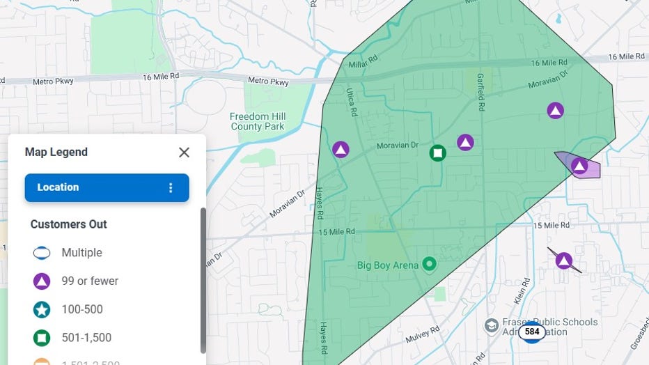
Snapshot from DTE Energy Outage Map.
2:40 p.m. Flood warning:
A flash flood warning for Macomb County has been issued until 4:45 p.m. today by the National Weather Service.
Heavy rain dropping between 2.5 and 5 inches have fallen with the expected rainfall rate to be 0.2 to 0.5 inches in one hour.
Some locations expected to experience flash flooding include Mount Clemens, Sterling Heights, Clinton, Macomb Township, Fraser, Clinton Township and Chesterfield Township.
The National Weather Service advises drivers to turn around, don't drown - be aware of your surroundings on flooded roads.
2:30 p.m.:
The Great Lakes Water Authority issued an alert, warning residents in SE Michigan - especially those in low-lying areas that heavy rainfall over the next 12 hours is predicted to be 1.5–2.0 inches across the region, according to the National Weather Service.
1:40 p.m.:
Strong storms rolled through Macomb County in the early afternoon hours of Wednesday with FOX 2 viewer Brian Kinzer sending video of the blowing rain conditions.
Kinzer's video was shot in Fraser. On Masonic between Utica and Grosebeck.

Wednesday storms roll through Macomb County
Video by Brian Kinzer in Fraser. This was taken on Masonic between Utica and Grosebeck.
1:30 p.m.:
A flood advisory was issued for Macomb County until June 18 with minor flooding expected due to heavy rain.
The National Weather Service says minor flooding is ongoing or expected to begin shortly in the advisory area.
Between 1 and 2 inches of rain have fallen with additional rainfall amounts of 1 to 1.5 inches are expected in the area. This additional rain will result in minor flooding, it said.
Locations expected to experience flooding include Warren, St. Clair Shores, Mount Clemens, New Baltimore, Richmond, Sterling Heights, Clinton, Macomb Township, Roseville, Eastpointe, Grosse Pointe Woods, Fraser, Harper Woods, Center Line, Utica, New Haven, Clinton Township, Chesterfield Township, Shelby Township and Ray Center.
1:12 p.m.:
A tornado warning was briefly issued for part of Macomb County by the National Weather Service.
Roseville, Fraser and Clinton Township were impacted by the strong storms capable of producing a tornado.
The sudden alert - which came without a tornado watch first - was lifted at about 1:20 p.m.
Stay ahead of the weather with the FOX 2 Weather app. It's free on your phone and provides live radar, alerts, and more.
The Source: This story is compiled from various alerts impacting Metro Detroit Wednesday due to the severe weather forecast.