


Cold Weather Advisory
Wind chills in the sub zero range this morning, single digits for the remainder of the day. Milder air by Monday. Meteorologist Lori Pinson has your forecast.


Arctic chill overnight as blast of cold hits SE Michigan
Rich Luterman has the forecast.


Metro Detroit warming centers: Where to stay warm during deep freeze
Though the snowy weather may have passed, the chilly temperatures are just beginning across Metro Detroit. Many community warming centers are opening up to help protect people from the cold.


Detroit water main break: Water authorities will split cost to repair homes, replace appliances
Everything to know about the massive water main break that flooded a Detroit neighborhood and froze families in their homes Monday morning.


Driver swept into floodwaters rescued by 3 linemen restoring power in Virginia
Three power linemen became heroes over the weekend when they rescued a motorist from a raging flood in central Virginia.


Cold stretch ahead!
Cold start to the week with highs in the teens and feel like temperatures falling below zero for a stretch!


Water main break leaves Southwest Detroit neighborhood underwater
A Southwest Detroit neighborhood is underwater Monday morning due to a water main break.

Metro Detroit weather: Arctic air and gusty winds combine for a week of below-average temps
As arctic air moves in today, the wind ramps up, making it feel much colder.


Much Colder Today
Wind chills in the single digits this morning becoming sub zero overnight as arctic air meets up with gusty winds. Lake effect snow completes the forecast today. Meteorologist Lori Pinson has details


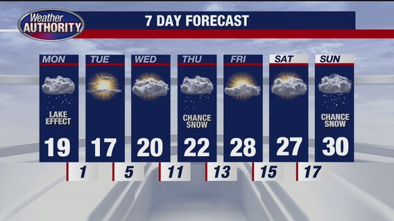
7-Day forecast with Rich Luterman
Rest of Sunday night, mostly cloudy brisk and cold with scattered snow showers low of 13 degrees. Monday: Mostly cloudy…. blustery and cold…. some snow flurries…. High 18 Tuesday: Sun and clouds…. COLD…. high 18 Wednesday: Mostly cloudy and COLD…. high 19 Thursday: Mostly cloudy…. a few flurries….high 23 Friday: Sun and clouds… not as cold…. high 27 Saturday: Lots of clouds… high 27 Sunday: Increasing clouds…. high near 30


Levee fails in Tennessee flooding; 8 dead in Kentucky as rescues continue
Historic flooding hit four states over the weekend, causing a Tennessee levee failure and killing at least eight, including a child, in Kentucky.


Snow Tapering off
This morning's snow continues to taper off, ending in lake effect snow showers early this evening. Bitterly cold temperatures start the work week. Meteorologist Lori Pinson has your forecast.


More snow Sunday!
Snow arrives early Sunday morning with steady snow between 6am and 10 am. Snow become more scattered with most spots picking up an additional 3"-6" of snow while areas closer to the lake shores around an additional 5"-7". Temperatures then get much colder!


Winter Weather Advisory Early
A wintry mix of freezing rain and snow downriver cuts down today's projected totals. Accumulating snow moves in this evening and overnight. Meteorologist Lori Pinson has your forecast.


Metro Detroit road conditions: Snowy weekend to blanket Southeast Michigan
The weekend is bringing Old Man Winter to Metro Detroit's doorstep, and that may lead to slick conditions for drivers.


St. Clair Shores Snow Brigade: 100 volunteers assist seniors with snow removal
More snow can mean more headaches when it comes to keeping your driveways and sidewalks cleared, especially for seniors who might not be able to do it themselves.


FOX 2 News at 6
FOX 2 News at 6 with Roop Raj and Taryn Asher


FOX 2 News at 6
FOX 2 News at 6 with Roop Raj and Taryn Asher


Two rounds of snow this weekend!
Snow arrives by 6am Saturday morning with the steady snow between 7am and noon! Saturday evening our second round arrives with a mix starting at 7pm through midnight! Then snow showers for the rest of Sunday! First round brings 1"-3" of snow while the second round brings 3"-6"! Grand total of 5"-10" for lots of spots with 3"-5" closer to the Ohio and Michigan state line!


Will Donald Trump end daylight saving time? Here's what he's said
As daylight saving time approaches, President Donald Trump has voiced support for ending the time change, calling it “costly" and “inconvenient." Will his administration take action?