Michigan winter 2024-2025 outlook: What we can expect from La Niña
DETROIT (FOX 2) - As winter approaches, the question on everyone’s mind is, "What kind of winter are we looking at?" It’s a great question! So much of our seasonal joy is wrapped up in how much we’ll have to shovel (and, of course, how deep the Detroit Lions go in the playoffs).
Last winter, 2023-2024, was a warm one. Heading into an El Niño pattern, we anticipated a significantly warmer and drier winter, and that’s exactly what we got.
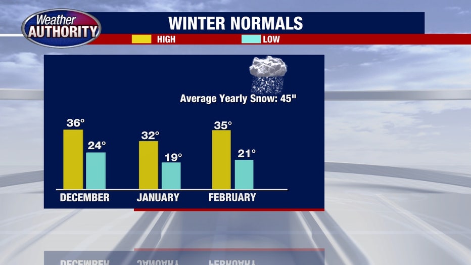
With an average high temperature of nearly 35 degrees, it was the fourth-warmest winter on record for Metro Detroit. Flint saw its warmest winter ever, while the Saginaw area tied for its warmest. We received only 20 inches of snow during December, January, and February, well below the seasonal average of about 35 inches (when including November and March, that number is almost 45 inches of snow).
RELATED: Farmers' Almanac winter outlook calls for 'copious amounts of snow, rain, sleet and ice'
While lighter shoveling was a nice break, some of my snowboarding friends were disappointed in the lack of good powder this year.
So, what can we expect heading into this season? To understand the forecast, let’s look at the global weather patterns that help us make seasonal predictions. While these global patterns will not determine every single element of winter, they do help give us a blueprint for what is typical in this formation.
Last year we were in an El Niño pattern and we have shifted now to the opposite of that, which is called La Niña.

What is El Niño and La Niña?
The climate patterns El Niño and La Niña affect global weather, especially in the Pacific region.
El Niño occurs when Pacific Ocean waters near the equator warm up, causing heavy rains in places like South America and droughts in Australia. It often brings milder winters to North America but can intensify storms in the western U.S.
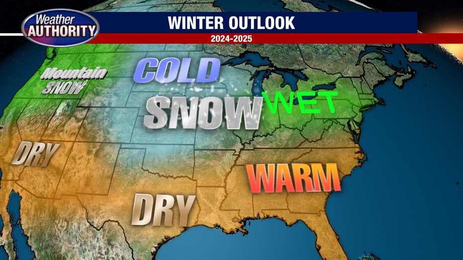
La Niña, on the other hand, cools Pacific waters, strengthening wind patterns. This frequently results in floods in Australia, drier conditions in South America, and in the U.S., cooler, wetter weather in the northwest with drier conditions in the south.

How will La Niña affect Michigan?
As we brace for a La Niña winter, areas to our south and southeast are expecting significantly above-average temperatures as well, but we’re looking at conditions closer to average or just slightly above average.
For us, that usually means highs around the mid-30s in December and February, with January averaging closer to 32 degrees. Average lows should fall between 20 and 25 degrees.
With La Niña, the Midwest often sees above-average precipitation. Whether that brings more snow or winter rain depends on the temperature.
For instance, if temperatures hover around 33-34 degrees, we’re likely to see winter rain; if they’re around 30-31°F, it could mean more snow. Timing out the exact arrival of the cold air and blast of moisture is exceedingly difficult this far in advance but the trends are what are important.

How much snow will Michigan get this year?
The combination of more precipitation yet higher temperatures would suggest a wetter overall winter in store for us. Considering that it’s extremely likely to get a blast of colder air, I would lean towards forecasting more snow this year than last year but some extra winter rain events (like we had last season) are also possible.
Looking back, the last time we experienced this kind of shift—from El Niño to La Niña—was in winter 1998-1999. That season began with a mild December, followed by a very snowy January with over 27 inches of snow, and cold, snowy weather lasting well into March.
If this year follows a similar pattern, we could see a relatively easy start to winter, but with a prolonged, snowier stretch from January into spring.
With our winter forecast sorted, we’re already looking ahead to the next big question: Will we have a white Christmas? We'll get to that later.

